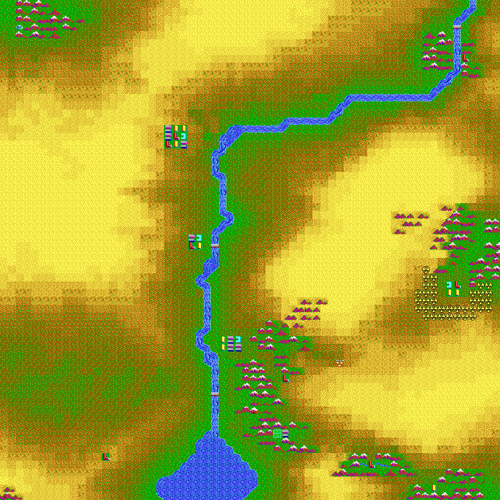
This is the main map of the Wasteland world. For Wasteland 2 see: Wasteland 2 world.
North and/or West of the central river locations include:
South and/or East of the central river locations include:
- Sleeper Base
- Darwin Village
- Quartz
- Rail Nomad's Camp
- Guardian Citadel
- Mine Shaft
- Agricultural Center
- Highpool
- Ranger Center
Real world comparison[]
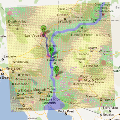
Using a composite of the main map and a Google map with scaled alignment of Las Vegas, Needles, and Quartz.
Las Vegas: West of the bend in the Colorado River and the Highway 93 bridge crossing.
Needles: West of the river and the Interstate 40 bridge.
Quartz: Quartzsite, East of the river and the Interstate 10 bridge.
Rail Nomad's Camp: West of Phoenix, Buckeye has multiple railroad tracks.
Guardian Citadel: South of I-10 (N of I-8) between Quartzsite and Phoenix in the mountains.
Mine Shaft: Mountains North East of Yuma.
Agricultural Center: South of I-8, perhaps "Ajo" on Highway 85.
Highpool: South of Phoenix, West of Tucson, there is a town named "Sells", also "Pisinemo Trading Post" to the North of Sells in the hills.
Ranger Center: South of Tucson east of I-19, closest prison is:
- State Prison Arizona, 10000 South Wilmot Road, Tucson, AZ
Savage Village: East of Ensenada, near a National Park labeled Juarez.
Darwin Village: North-East of Phoenix, South of Winslow. Mountains are in a odd place to pick anything for certain.
Sleeper Base: The bridge North could be I-70, and the base would be South between "Halls Crossing" and "White Mesa"
Base Cochise: North-East of Death Valley, "Lida Junction Airstrip" at the intersection of HWY 95 & 266.
Oddities:
- The Gulf of California seems to have eroded to the North.
- The desert and mountains West of the Savage Village are in the Ocean (global warming?).
- Phoenix must have been completely destroyed, perhaps why there is radiation West of Darwin.